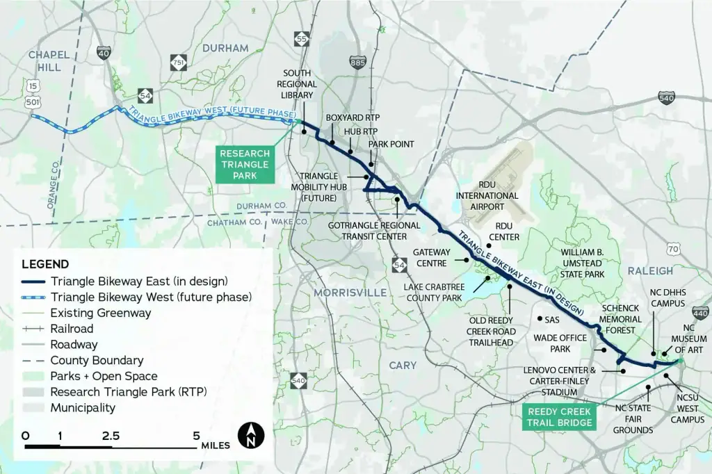
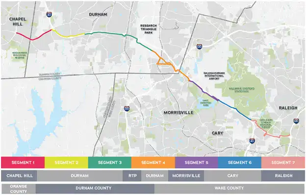
Triangle-area agencies worked together to plan a regional, 23-mile shared-use path linking Raleigh, Cary, Morrisville, Research Triangle Park, Durham and Chapel Hill along the I-40 and NC 54 corridor.
The path is intended to connect residents and visitors with jobs, popular destinations, trail networks, transit and other destinations across the region. Although the project is called a bikeway, it is planned as a shared-use path suitable for people of different ages and abilities traveling both on foot and by bike.
Shared-use paths are paved trails separated from vehicular traffic and designed for pedestrians and cyclists.
After extensive analysis and community input, the project team evaluated more than 100 miles of potential routes before developing the recommended alignment. Potential routes were studied to understand challenges, constraints and opportunities along the corridor.
The planning effort took approximately 18 months. Triangle West TPO and CAMPO adopted or endorsed the study in spring and summer 2022, with the Triangle West TPO Policy Board endorsing the final report on June 8, 2022.
Study Report & Technical Appendices
Study Report & Technical Appendices
Funding sources and implementation considerations for bicycle and pedestrian infrastructure.
Detailed concept plans developed for portions of the recommended alignment.
Additional information supporting project cost estimates.
Supporting materials documenting the study’s community and stakeholder engagement.
Additional design references supporting the study recommendations.
From Study to Implementation
The Triangle Bikeway Study established a regional vision and recommended alignment, but implementation requires additional design, funding and coordination among the agencies responsible for different portions of the corridor.
Following completion of the study, the project was divided into eastern and western implementation efforts so each portion could advance through additional design and funding work.
Triangle Bikeway East
Triangle Bikeway East
The eastern portion extends through the CAMPO area toward Raleigh.
CAMPO began the Triangle Bikeway East Design Project to refine the alignment and advance the project toward future construction funding. Current work includes continued coordination with Wake County, Research Triangle Park, NCDOT, Durham County, Durham, Cary, Morrisville and Raleigh.
Public and stakeholder engagement for the current design phase was completed in February 2026. CAMPO and Triangle West TPO endorsed the East alignment in June 2026, and work is continuing toward approximately 30% design plans anticipated in early 2027.
Triangle Bikeway West
Triangle Bikeway West
The western portion continues from Research Triangle Park toward Durham and Chapel Hill.
Triangle West TPO’s next steps include advancing an implementation study and 30% design for the western segment, developing design work between Chapel Hill and RTP Park Point, and identifying construction and funding strategies.
The project also continues to intersect with other regional transportation work, including NC 54 corridor planning and coordination with the eastern design project.

Project Contact
David Miller
Principal Planner, Triangle West TPO
A Regional Project
The Triangle Bikeway crosses multiple jurisdictions, which means implementation depends on continued coordination among local governments, transportation planning organizations, NCDOT and other regional partners.
The project is also incorporated into the region’s current long-range transportation planning. Destination 2055 describes the Triangle Bikeway as a planned 23-mile shared-use path connecting jobs, destinations and trail networks along the I-40 and NC 54 corridor.
For Central Pines, the project is part of broader work to strengthen walking, biking and regional transportation connections.