Option 1

Planning for Regional Bicycle & Pedestrian Connections

2019

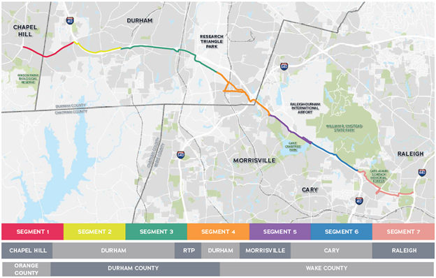
In 2019, Triangle area agencies worked together to plan a regional, 23-mile, shared-use path linking Raleigh, Cary, Morrisville, Research Triangle Park (RTP), Durham, and Chapel Hill following the I-40 and NC54 corridor. The path will connect Triangle residents and visitors to jobs, popular destinations, trail networks, transit, and more, across the region. While the project is called a bikeway, it will be a shared-use path suitable for users of all ages and abilities both on foot and by bike. Shared-use paths are paved trails that are separated from vehicular traffic and used by both pedestrians and cyclists. 

2022

After extensive analysis and collection of significant community input, the project team evaluated over 100 miles of potential routes to develop a recommended alignment route. During the evaluation process, potential routes were studied to understand challenges and constraints. Both DCHC MPO and CAMPO Boards adopted the Triangle Bikeway Study in Spring/Summer of 2022

[link to final document]

2024

In order to further evaluate implementation and prepare the project for potential funding opportunities, the project was split and currently in different phases of design. For the latest information about the eastern and western portions of the project, please visit the websites below. 

Current

Triangle Bikeway: West
(DCHC MPO)

Regional Advisory Committee
(CPRC)

Triangle Bikeway: East
(CAMPO)

Triangle Bikeway: DCHC MPO Status Map


Option 2

2019-2022 Triangle Bikeway Study

Triangle Bikeway Map

Triangle area agencies worked together to plan a regional, 23-mile, shared-use path linking Raleigh, Cary, Morrisville, Research Triangle Park (RTP), Durham, and Chapel Hill following the I-40 and NC54 corridor. The path will connect Triangle residents and visitors to jobs, popular destinations, trail networks, transit, and more, across the region. While the project is called a bikeway, it will be a shared-use path suitable for users of all ages and abilities both on foot and by bike. Shared-use paths are paved trails that are separated from vehicular traffic and used by both pedestrians and cyclists.

After extensive analysis and collection of significant community input, the project team evaluated over 100 miles of potential routes to develop a recommended alignment route. During the evaluation process, potential routes were studied to understand challenges and constraints. Both DCHC MPO & CAMPO Boards adopted the Triangle Bikeway Study in Spring/Summer of 2022. 

FINAL REPORT & APPENDICIES

2022-2024 Implementation Strategy

In order to further evaluate implementation and prepare the project for potential funding opportunities, the project was split and currently in different phases of design, consistent with the results of the Triangle Bikeway Study. To learn more, visit agency websites below.

Triangle Bikeway: West
(DCHC MPO)
Contact: David Miller
david.miller@dchcmpo.org

RAC
(CPRC)
Contact: Lindsay Whitson
lwhitson@centralpinesnc.gov

Triangle Bikeway: East
(CAMPO)
Contact: Cara Russell
cara.russell@campo-nc.us

Blurb

Bike & Pedestrian Page

Triangle Bikeway Study - 2021-2022

The Triangle Bikeway Study planning effort resulted in design and construction recommendations for a future 23-mile bicycle path linking Raleigh, Research Triangle Park (RTP), Durham and Chapel Hill along I-40 and NC 54. The bikeway will connect Triangle communities making both short and long bike trips for work, play and daily errands possible. Ideas from residents, other community members, and key stakeholders helped shape the plan. Agencies across the region worked together in the planning process, which took approximately 18 months.

The CAMPO Executive Board endorsed the Triangle Bikeway Study Final Report at their April 20, 2022 meeting. The Triangle Bikeway website is now maintained by Triangle Council of Governments (TJCOG), which is transitioning to the name Central Pines Regional Council). The current website link is located here: http://trianglebikeway.com. Final Report - Triangle Bikeway Study

For additional information, please email Cara Russell, Senior Transportation Planner.

Bike & Pedestrian Page

The Triangle Bikeway Study planning effort resulted in design and construction recommendations for a future 23-mile bicycle path linking Raleigh, Research Triangle Park (RTP), Durham and Chapel Hill along I-40 and NC 54. The bikeway will connect Triangle communities making both short and long bike trips for work, play and daily errands possible. Ideas generated from residents, community members, and key stakeholders through the study’s public engagement strategy helped shape the plan. Agencies across the region worked together in the planning process, which took approximately 18 months. The DCHC MPO Policy Board endorsed the Triangle Bikeway Study Final Report at their June 8, 2022 meeting.

The Triangle Bikeway website is now maintained by the Central Pines Regional Council (formerly the Triangle J Council of Governments (TJCOG)). The current website link is http://trianglebikeway.com. Final Report - Triangle Bikeway Study For additional information and updates, please email David Miller, Transportation Planner, at david.miller@dchcmpo.org or via phone at 919-503-4118.